Drone Inspections
Get to know the various drone technologies we use to obtain the right insights in every situation.
With the help of various sensor technologies, drones can provide a much richer data-set that allows for better decisions to be made. And in combination with their speed, cost-efficiency, safety and versatility, it is now possible to inspect your assets on a more regular basis. So instead of reacting to issues, areal asset intelligence allows for a more proactive approach. Find out how the different technologies we use can help you to obtain the insights you need to start working faster, safer and smarter.
Fotogrammetrie: een uniek perspectief van bovenaf
Lucht fotogrammetrie is een methode om vorm en locatie van objecten en gebieden door metingen in foto’s te bepalen. Dit levert hoge kwaliteit beelden, 2D Orthomosaics en 3D modellen op.
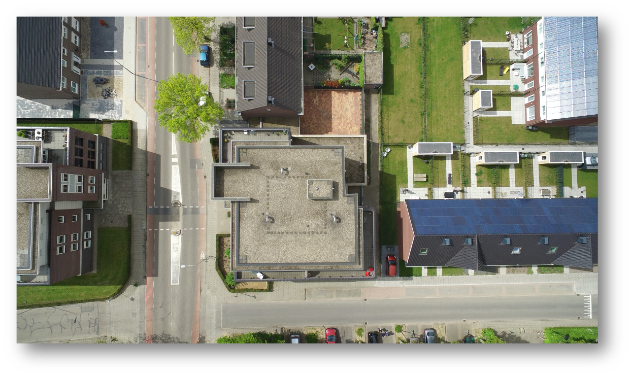
1. Ultra HD-beelden
Drones zijn wendbaar en bieden veel flexibiliteit, waardoor zelfs de meest lastig bereikbare plekken gemakkelijk, veilig en kost-efficiënt geïnspecteerd kunnen worden. Dit soort drone inspecties leveren ultra scherpe foto’s en video’s waarop de kleinste details goed waarneembaar zijn.
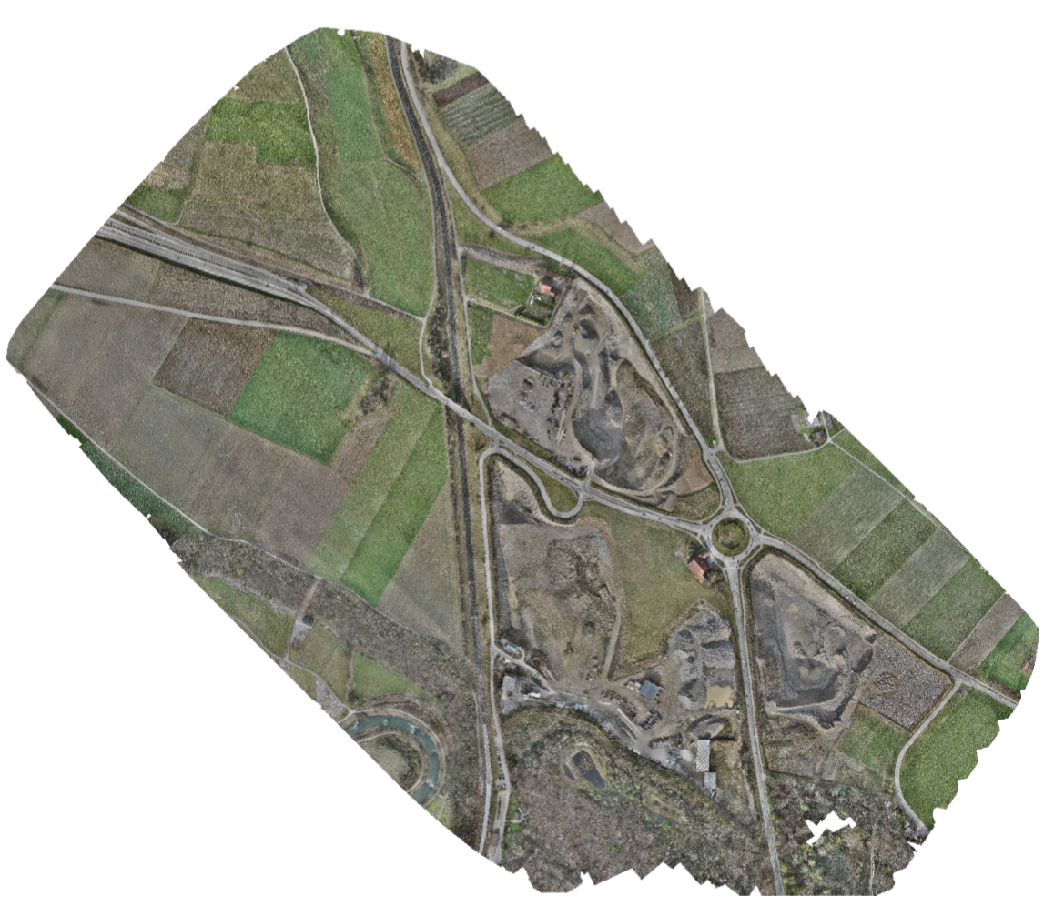
2. Orthomosaic map
Een 2D foto-reconstructie van een gebied, opgemaakt uit honderden tot wel duizenden in elkaar verweven foto’s. Het resultaat is een gedetailleerde kaart voorzien van een constante grootte, welke alle bijbehorende kenmerken op de exacte locatie weergeeft. Gepaard met een hoge nauwkeurigheid van wel 1cm per pixel, is deze vele malen accurater dan conventionele satellietbeelden. Het is hierdoor ook mogelijk om ver op de kaart in te zoomen zonder enig kwaliteitsverlies. Al met al is een orthomosaic een goede manier om snel en efficiënt een groot gebied getailleerd in kaart te brengen.
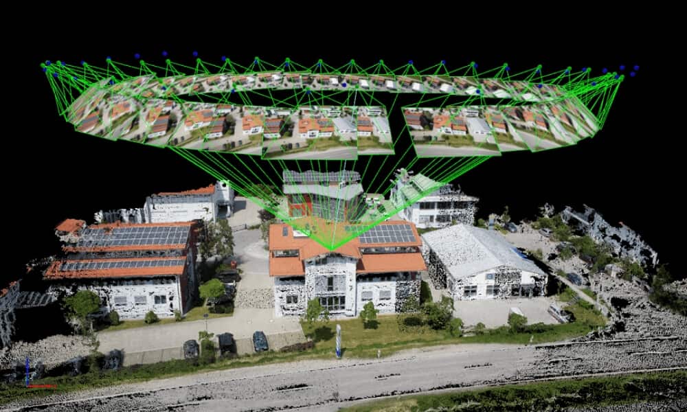
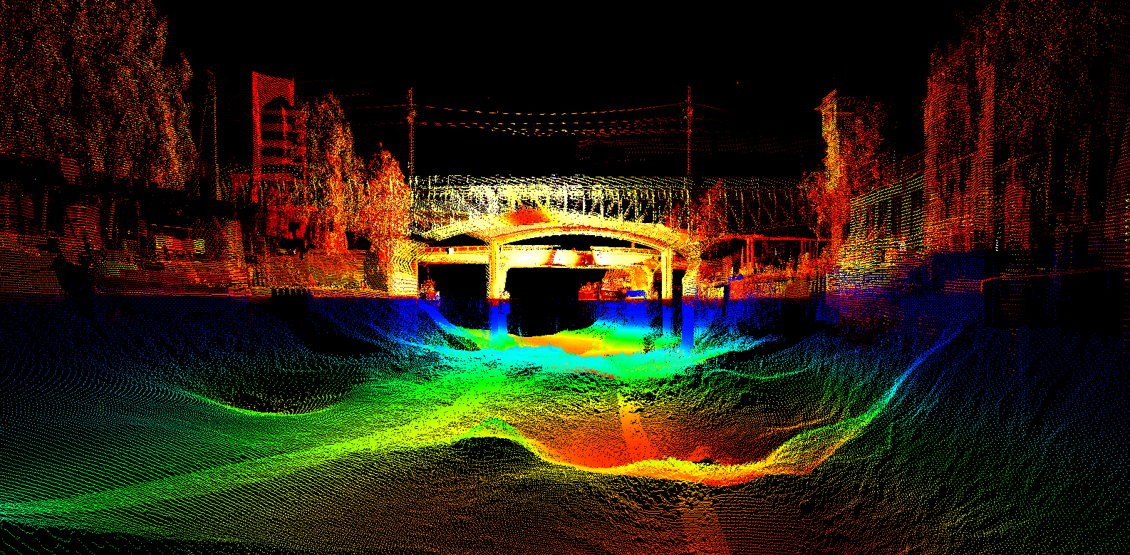
3. Puntenwolken
Een 3D model bestaand uit duizenden of zelfs miljoenen geo-gerefereerde punten. Het resultaat is een uitermate gedetailleerde reconstructie van een asset of gebied aan de hand van hoogtes, texturen, vormen en kleur informatie voor elk punt. In de wereld van asset-management worden puntenwolken vaak gebruikt om een digitale replica te maken van een asset, zodat managers niet constant op locatie aanwezig moeten zijn. Hierdoor is het mogelijk om een asset van praktisch iedere invalshoek eenvoudig te inspecteren.
LiDAR: wanneer het kleinste detail er toe doet
LiDAR staat voor ‘Light Detection and Ranging’ en is een technologie die de afstand tot een object of oppervlakte bepaalt door het gebruik van laserpunten. Hiermee kunnen gedetailleerde kaarten en 3D puntenwolken gemaakt worden op basis van gehele gebieden of individuele assets. Precisie staat hierbij centraal, gezien elke vierkante meter wel 100 tot 500 punten kan bevatten. Hierdoor kan je met LiDAR de kleinste nuances detecteren welke normaalgesproken onopgemerkt zouden blijven.
Zo is het bijvoorbeeld mogelijk om de aanwezige vegetatie en begroeiing te detecteren en zelfs te verwijderen uit het digitale model. Ook is LiDAR ideaal voor omgevingen met weinig tot geen licht, zoals dat vaak in tunnels het geval is.
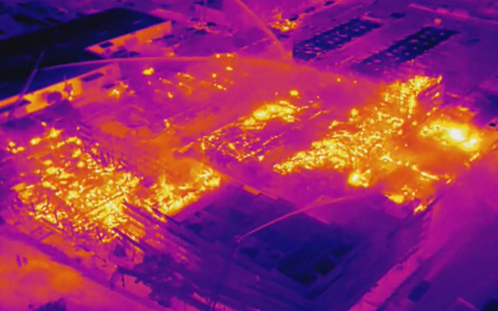
Thermisch: zie wat er achter de schermen speelt
Door assets of gebieden te meten op basis van relatieve temperatuurverschillen, kunnen verborgen gebreken plotseling onthuld worden. Thermische sensors meten namelijk diverse soorten schades welke niet direct zichtbaar zijn voor het blote oog. Denk hierbij aan vocht schade, water lekken, elektrische problemen, problematische temperatuur variaties, en energie / isolatie inefficiënties.
Besloten Ruimtes: voor de meest moeilijk bereikbare plaatsen
Het inspecteren van besloten en nauwe ruimtes is veelal gevaarlijk, tijdrovend en kan al snel hoog in de kosten oplopen. En eenmaal binnen is het altijd nog maar te bezien of een inspecteur door belemmering de inspectie volledig en correct uit kan voeren. Wanneer het op besloten en nauwe ruimtes aankomt, zijn drones tot wel vier keer zo snel als handmatige inspecties. Onze drones voor deze doeleinden zijn uitgerust met LED verlichting, professionele camera apparatuur en een beschermende kooi van carbon fiber.
Grondradar: inzichten van zowel boven, als beneden het oppervlak
Met de traditionele werkwijzen is een grondradar scan niet alleen zwaar, tijdrovend en soms gevaarlijk werk, maar kan het ook al snel in de kosten oplopen. En in sommige gevallen kunnen moeilijk toegankelijke gebieden problematisch uitpakken. Vanuit de lucht kunnen zelfs de grootste en moeilijk begaanbare oppervlakken snel en gemakkelijk gescand worden. Vanaf een bepaalde hoogte is de grondradar namelijk toepasbaar op grond, ijs, stenen, stromend water, gebouwen en vele andere structuren.
The Next Step
Questions? Or maybe interested to know what kind of drone inspection would best suit your industry or next big project? Let’s get in touch!